Jasper National Park
More than hundred years ago forest park and town was named Jasper after popular fur trading post operator Jasper Hawes. Archeological evidence indicates people lived in the area as many as 10000 years ago. Jasper National Park is an area of dramatic mountain peaks and expansive valleys. Many of the mountains rise to elevations above 3000 metres. Mt. Columbia, the highest peak in Alberta, is 3782 metres, mount Robson – in British Columbia is 3954 meters. The lowest point in the park, 985 metres above sea level, lies near the park’s east gate. The park includes the glaciers of the Columbia Icefield, hot springs, lakes, and waterfalls .
More than four-fifths of the park is drain by Athabasca River. From the Columbia Glacier the Athabasca flows north and east through the park for nearly 150 kilometres. Ten other moderately-sized rivers and smaller creeks augment its volume over this distance. The Athabasca is one of the more significant rivers which flow from the mountain toward the Arctic Ocean. The portion of the Athabasca which lies within Jasper National Park has been designated as a Canadian Heritage River. The United Nations created the Canadian Rocky Mountain Parks World Heritage Site partly because of the incredible diversity of animals found here. Jasper National Park is home to 67 species of mammals, 20,000 types of insects and spiders, 40 types of fish, 16 species of amphibians and reptiles, 277 species of birds.
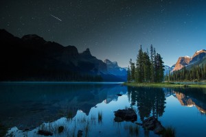
Maligne Lake is one of the most beautiful lake in Canadian Rockies the second largest glacier-fed lake in the world It is famous for the colors of its waters. Lake located 44 km from Jasper. It is 23 km long, surrounded by glaciers Peaks Mountains. The Highest peak in the area is Mount Brazeau. The Lake takes its name from French word for malignant or wicked. This name soon spread to the canyon in Jasper and river, mountain range. Maligne River arising at Maligne Pass and flows underground for 15 km and resurfaces near Maligne Canyon. This section of makes the Maligne river one of the world’s largest sinking river. This lake was well known to First nations people as Chaba Omne ( Beaver Lake). The first European who sees the lake was Henry McLeod, who worked for CPR. In 1928 Donald Philips build the Boathouse to accommodate his fishing business. The same year he finished creating first Maligne lake boat tours which are still operating by his family members.
Maligne Lake is the most photographed spots in Canadian Rockies. It gets the name from two young lovers from feuding tribes who used to meet secretly on the island. When the father of young girl found out about affair, he banned her from ever return to the island. Her lover continues to return to Spirit Island through his life, hoping to meet his love again. She never came and he died on the Island. His spirit still resides on the island. On the road to Maligne Lake you will drive by Maligne Canyon and Medicine Lake. Maligne Canyon depth is more than 50 meters; it is covered by limestone formations. Maligne River flows underground from Medicine Lake till it reaches Maligne canyon. There are six bridges build across canyon since 1914. The spectacular canyon views are near the first and second bridge. The tallest waterfront is near the second bridge.
Athabasca Falls is 23 meters in height and known for its force due to the large quantity of water falling into the gorge. Icy water starts below the falls to travel downstream on the Athabasca River to Jasper.
Photo credit: Parks Canada/R.Bray & Jeff Barlett/Tourism Jasper


